Day 1 (Saturday, 18-7-98)
Off-loading some surplus luggage and paying SFr 4.00 we were off to the railway station to buy a ticket to Luzern (SFr 41 return) so that we could climb to the top of Pilatus. At the ticket counter we were informed that the next train leaves in one minute. We reached the train just in time and jumped in with a second or so to spare, not taking note of the fact that we climbed into 1st class, that cost us another SFr 4.00 each, which we rather paid then schlepp our rucksacks down four wagons. In Zürich Hauptbahnhof it was also, take your luggage and see to it that you get to platform 3 pronto. The trains in Switzerland don't wait for no-one, when it's time to depart they depart on the second.
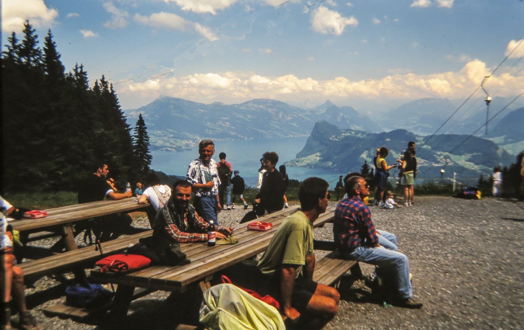 Moving at high speed and very softly through the beautiful landscape of Switzerland we soon arrived in Luzern and got out. After some inquiring we boarded the bus to Kriens, disembarking at the Linde stop. This is the location of the lower cable car station. We didn't use it, we are far too tough for going up by cable car (it was probably also too expensive for our liking). Proudly we walked past the station with our heavy rucksacks. But, shit, it went up and up without giving us a break by introducing some horizontal bits. Soon we were resting, consuming my Blueberry Yogurt, that I had bought at the railway station, it gave me some energy, but not enough. Up and up we went through lovely forests.
The next stop was at a picnic table for some coffee. Here it was discovered that my cup had been smashed up during the air transport and was of no use. I made a new cup by cutting out the lid from a cool drink tin. At the next stop we didn't have to make coffee ourselves, we ordered a coffee for me (F2.60) and a beer for Jim (F3.80), it was a inn situated conveniently on our hiking route.
 At this stage some doubts were already developing about making it to the top. Our only chance was to hide the rucksacks in the bushes and carry on un-hindered by a heavy rucksack. This we did and made it to the foot of the impressive piece of huge rock forming the top of Pilatus, without an obvious way up until one gets very close. There is a way and also a warning that some of the route requires climbing and in general is not for the fainthearted. This then was our excuse for not pushing higher, it was already 15h00. At this point we were at close to 1500m, i.e. it would have been another 500m higher to go. Also in 1962 we didn't do the mountain in one day, on Saturday we went to about 1400m and on Sunday all the way to the top and down again.
Watching some mechanical bob sledding for a while and consuming a cooldrink at SFr 5.00 each we started down to collect our bags. Picking them up we went down looking for a spot where we could put up the tent without being seen by any casual passerby. And we eventually did find the perfect spot, a wood cutter's shelter, it had a bench and a table all made of solid wood. This meant we didn't have to put up the tent, we slept under the table.
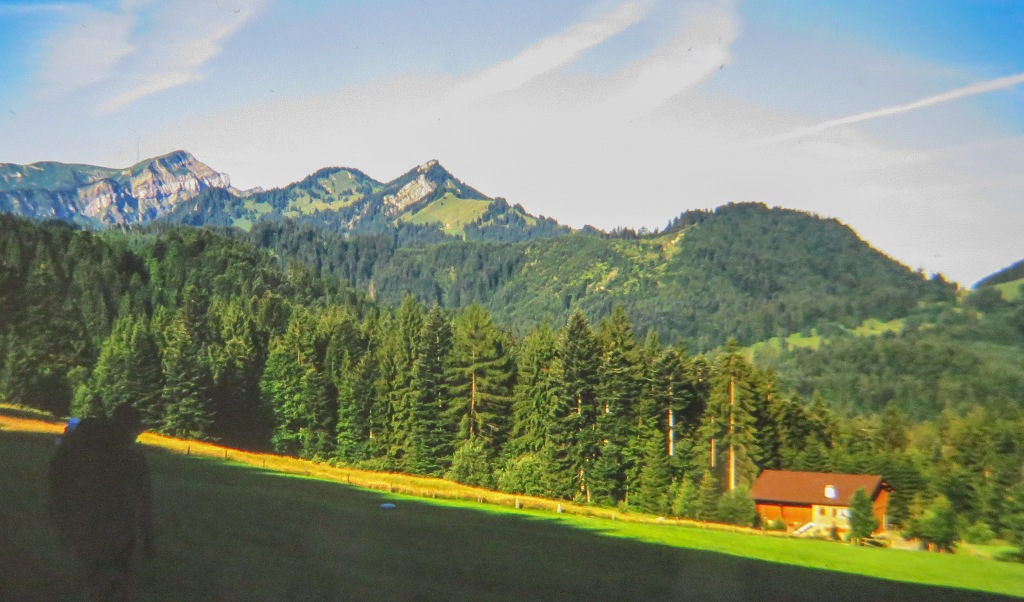
Some general observations: most of the people one meets on the mountain are Swiss (what a surprise), they are all very friendly and everyone greeting with a Grüizi or a different greeting that I hadn't come across before 'Hinauf', it means sort of 'let's get to the top'. One thing that was noticeable were the number of single woman going up the mountain, and going at a speed that left us standing. Some of the Swiss are very talkative and I had to remember my Swiss-German again in order to understand them, I managed. I must say I envy them about having such beautiful scenery and mountains right at their door step. 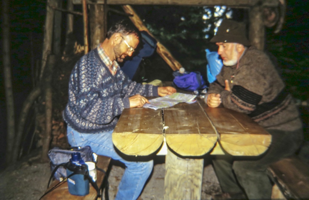 I also envy them about having such a well organised country, but then, of course, this also comes at a price of having to be disciplined. We had to marvel at the houses and farm buildings we saw on the mountain, everything was neat and tidy, Eleni would love it.
For general interest, here is an extract from the Muirhead Guide-Books 'Switzerland', printed 1923:
MOUNT PILATUS (6995ft) forms a long rugged ridge to the S.W. of Lucern, and is a mountain of gloomy, precipitous character, with eight or nine peaks. It was known until the 15th century as the Frackm'ünd (Fractus Mons), but a curious tradition connects it with Pontius Pilate, whose corpse, after being successively thrown into the Tiber, the Rhône, and the Lake of Geneva, is said to have found a final resting place here in a gloomy tarn. The gathering of storm-clouds on the summit has been attributed to the disturbance of his unquiet spirit. It may be, however, that the name is only a corruption of Pileatus, 'capped' with clouds. A rounded cloud-cap, known as the 'hat' of Pilatus, is believed to be a sign of fine weather, while a long stratified cloud presages rain. The flora of Pilatus is particularly rich (more than 300 varieties).
Day 2 (Sunday, 19-7-98)
Our train that we had selected to take us back to Zürich was going to leave the station at 11h10, the one at 12h10 would also have done it, we just wanted some safety factor. So we walked down fairly rapidly only stopping once for a bit of a wash in a river and for some coffee. Once in town everything happened very smoothly, waited for a few minutes for the bus, got to the station and used the few minutes available before the train left to buy some Gorgonzola cheese and Blueberry yogurt. With us in the bus was a real Swiss hiker, hanging on his relatively small rucksack he had crampons and a ice ax plus other bits and pieces, this guy was going to do some serious stuff. He also had his dog along. On being questioned where he was off to he explained that he was going to visit a few people in Central Switzerland, nothing serious since he was still nursing a broken leg from last year. I, at least, was certainly impressed, minimum equipment and off into the high Alps. He was either extremely competent or a fool, I like to belief the first one.
The train, another smooth and fast ride, took us direct to the airport. On the way I tried to estimate the speed the train was traveling at and got to something between 150 and 180 km/hr, not bad, eh?
We had plenty of time and sat around the station for a bit consuming some cooldrinks and a hot-dog, what happened to the more traditional Bratwurst und Brötchen? I don't know, even the Swiss are becoming americanised.
The flight to Kopenhagen was no problem, the weather was fine and I could look down on the Vaterland. One landmark that I regocnised was the car test track at Wolfsburg, that is where the Volkswagen comes from. The Baltic Sea was beautiful, all blue with lots of ships on the water.
We knew exactly where we would have to go, my friend Daryl at work had given me the information about where he had camped the previous year. So all we did was go to information, point a finger at the right place on the map and woola: 'take the bus to the main station and then the S-tog (city train) from there to Vallensbaek', get off the train and walk to Tangloppen camping place, no hassle, and so it was. The only fly in the ointment was the price, DKr 33 for the bus, DKr 22 for the S-tog and than DKr 123 for the two of us to camp for the night. By the time we were finished and back at the airport it had cost us DKr 177 (R168) per person. But lets not moan about the prices, the reception was very friendly and we took note of the fact that everyone in Denmark speaks English fluently, we had no problem whatsoever communicating.
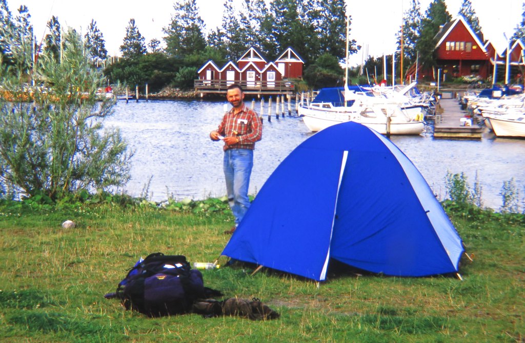 The camping place was full, with only a bit of space left on the far end. It was enough room to put our tent right at the water's edge. I was intrigued by the large number of holiday makers and noticed that many of them originated from Sweden, I suppose I can understand that, for them going to Copenhagen is going to the sunny south. My foot, I didn't see any sun, it was miserable, Greenland has more sun then this place. Perhaps I am a bit unfair, my sample consisted of two days, statistically not very significant.
After the tent was up and I had consumed a cooldrink that I had bought for DKr 15 we took a short walk down to the Baltic coast. It was an historic moment, the last time my feet touched the Baltic Sea was in 1960. That is where I spent my last holiday before I left East Germany.
The water was clear and most likely unpolluted and the temperature was not too bad, only the weather was gray and cool, so not very inviting for a swim.
Day 3 (Monday, 20-7-98)
 Before we move off to fly to Greenland, let's first discuss: why Greenland? This happened a few years before when I was on a flight from Frankfurt to Los Angeles. The pilot brought to our attention that we are flying over Greenland. Looking out the window I was absolutely amazed at the landscape and decided there and then that one day I must hike in Greenland. And thus it came about
We had to make sure that we get to the airport on time and started walking to the S-tog at 6h00, but this time we walked to Ishoj station, which from a more detailed map at the camp site we had identified as closer than the one we got off from the previous day. But this also put us into the next zone and we paid DKr 27,50 each to get to the main station. Every connection worked out without much delay and we got to the airport with lots of time to spare. Check-in was not in progress yet and I got us some coffee from the local in, shock!, DKr 19 each for a @#$%& cup of coffee, its the last time I will buy coffee at that place. To revenge ourselves we filled our pockets with sugar cubes, which we knew would come in very handy for the hike.
We were in front at the check-in and once through passport control had time to do some last minute shopping, I got some Esrom cheese for the hike and some ice tea cooldrink (very nice, can be recommended) and a sandwich as breakfast. I could have saved that money because we got a great meal on the plane, possibly the best I have ever had on an airplane.
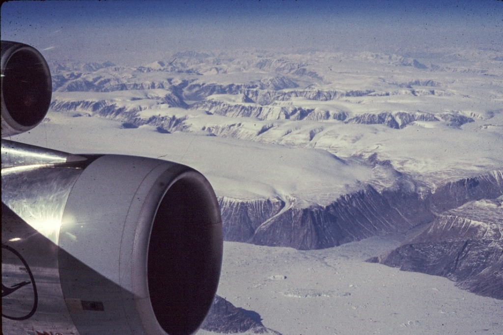
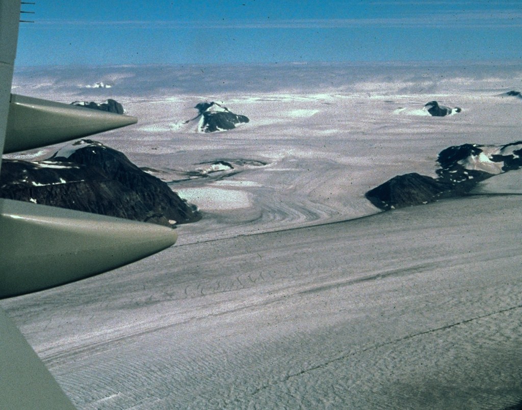 The flight was very pleasant and time was filled (4 or 5 hours) with being served this, that and lunch and after dinner drinks and liquid refreshments, it only stopped when Greenland was in sight. And what a welcoming! All along we had cloud cover and only as we were coming over Greenland did the sky open providing us with a magnificent view of the inland ice cap to the north of Narssarssuaq with the occasional mountain sticking out from it. Below the ice, to the south, was the ice free landscape, covered in lakes of all sizes by the hundreds, it caused me to state that I will not carry any water, there is water at every corner.
Coming in to land was another adventure, it looked like on the first approach to Narssarssuaq the plane was too high, he flew over the landing pad from the fjord and had to make a 360° turn to come around once more. It looked like the wings were going to scrape the mountains. Next time round we were low enough for the pilot to attempt a landing and he succeeded.
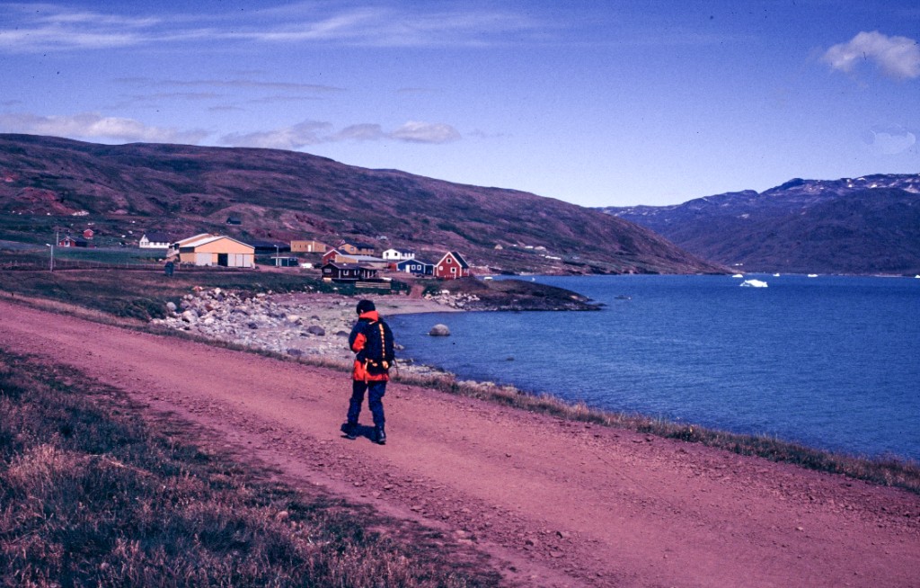
 Greenland greeted us with warm sunshine, warm enough that I could roll up my sleeves. And the first thing to organise was to get over to the other side of the fjord to Qassiarsuk. I had tried to get a booking for the ferry beforehand but the Copenhagen office said it was fully booked. On inquiring we made our way down to the hotel to speak to Arctic Adventures, a tourist company, they were taking a group over and for a fee of DKr 125 each they would take us along. Everything happened very quickly, I still had to go to the shop to get some methylated spirit, I managed to acquire the last two bottles. That should see me through the two weeks here easily. On returning to the hotel Jim had already loaded the rucksacks onto the bus and off we went down to the harbor.
Confusion, which boat is supposed to ferry us over? The riddle was solved when the next bus arrived with the tour group, Jim had caught the bus too early.
The trip over the fjord is not very long, possibly 15 minutes. Once on the water I had to roll down my sleeves, a cold wind was blowing over the water, it possibly got cooled by passing over one of the glaciers. There were pieces of ice floating in the water, not large enough to be called ice bergs. This ice either originated from one of the glaciers that dumps its load into the fjord or actually comes floating down from the north.
Our next potential problem that we had to see to was the ferry that we were going to take from Narsaq back to Narsaq back to Narssarssuaq to catch our return flight. Although I had verbal confirmation from the office of Greenland Travel in Copenhagen I never received the promised fax. The best place to sort it out would have been on the Narssarssuaq side of the fjord, that is where Greenland Travel has a representative, but time didn't allow to make the necessary arrangements. I fortunately had the number and phoned over to the other side from the telephone at the KNI shop. It was not possible to get a definite answer, the person who knows was not there. So, at least, I left a message with our details and said I would phone again when we get back to Qagssiarssuk.
Qagssiarssuk used to be called Brattahlid and is the place where Eric the Red established his settlement back in 982.
 It was now getting well into the afternoon and we wanted to leave the settlement behind us. This we did by following the road taking us north along the shores of the fjord. To our, or at least my, surprise we found water to be a problem, it obviously hadn't rained for a few days and the streams we crossed were dry. I had taken some water from the hostel in Qagssiarssuk but found that that was chlorinated to extinction. What I don't understand is that the water had to be chlorinated, all the lakes and streams that we came across in Greenland were perfectly drinkable and the water for Qagssiarssuk came from one of these mountain lakes.
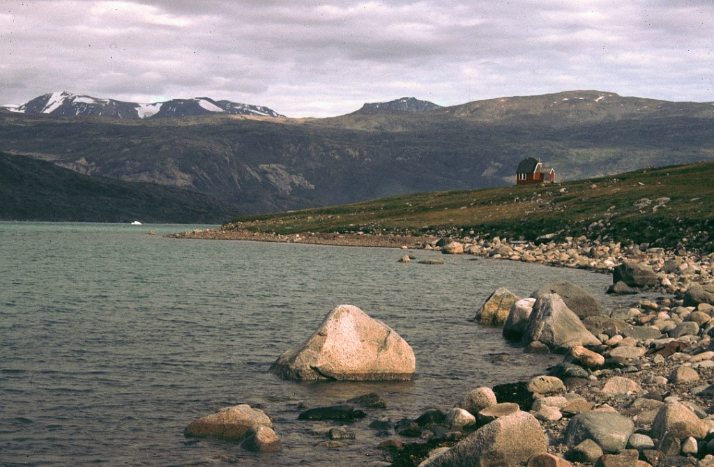 Camp was set up at the first running stream we eventually came to near a sheep farm called Qinarmuffik. The tent was put up on a horizontal piece of grass at the waters edge. It was still early and we occupied the rest of the afternoon and early evening by exploring the shore line in both directions. One of the brochures I had consulted before the trip talked about the pristine environment of Greenland. After the walk I had to wonder, the sheep farmers obviously didn't read that brochure, we found all sorts of rubbish: plastic, fencing wire, wood, empty shotgun cartridges, nails, steel rope and even bottles. Its all things that had been used on the farm and discarded or just left wherever it had been used.
For the evening we made ourselves a little fire, wood we had plenty, thanks to the Greenland farming community. Sitting around the fire and drinking Greek coffee was a fitting conclusion of the evening. I don't know what time we went to bed, it must have been around 22h00.
next page
return to home page